HA GIANG - THE MAJESTIC BORDERLAND
Written by
Manager
Publish on
11 tháng 7, 2025
Table of contents
Ha Giang is remote, sparsely populated, filled with steep mountains, steep slopes, deep valleys, connected by long stretches of curvy roads, bordered on two sides by rocky terrains and small crops.
This is home to many ethnic groups such as Hmong, Tay, and Dao who still live in their traditional houses, wear their traditional clothing, and find a way to adjust to the harsh environment, trade with each other, and raise their children and grandchildren.
As you reach closer and closer, the mountains become taller, valleys become deeper, and landscapes become more and more striking. Diverse colors of communities paint on the green and dark nature backdrop.
Topography - rugged landscapes
Ha Giang topography is known to be majestic, formed by high rocky mountains, deep valleys. As the northernmost province that shares the border with China, the elevation can range dramatically from 200 meters in valleys up to 2000 meters in peaks. There are various passes connecting regions.
The terrain is rugged, with limestone formations including cliffs, sinkholes, gorges. Here, the beautiful, jade-colored Nho Que river flows through deep canyons and brings water to some farms.
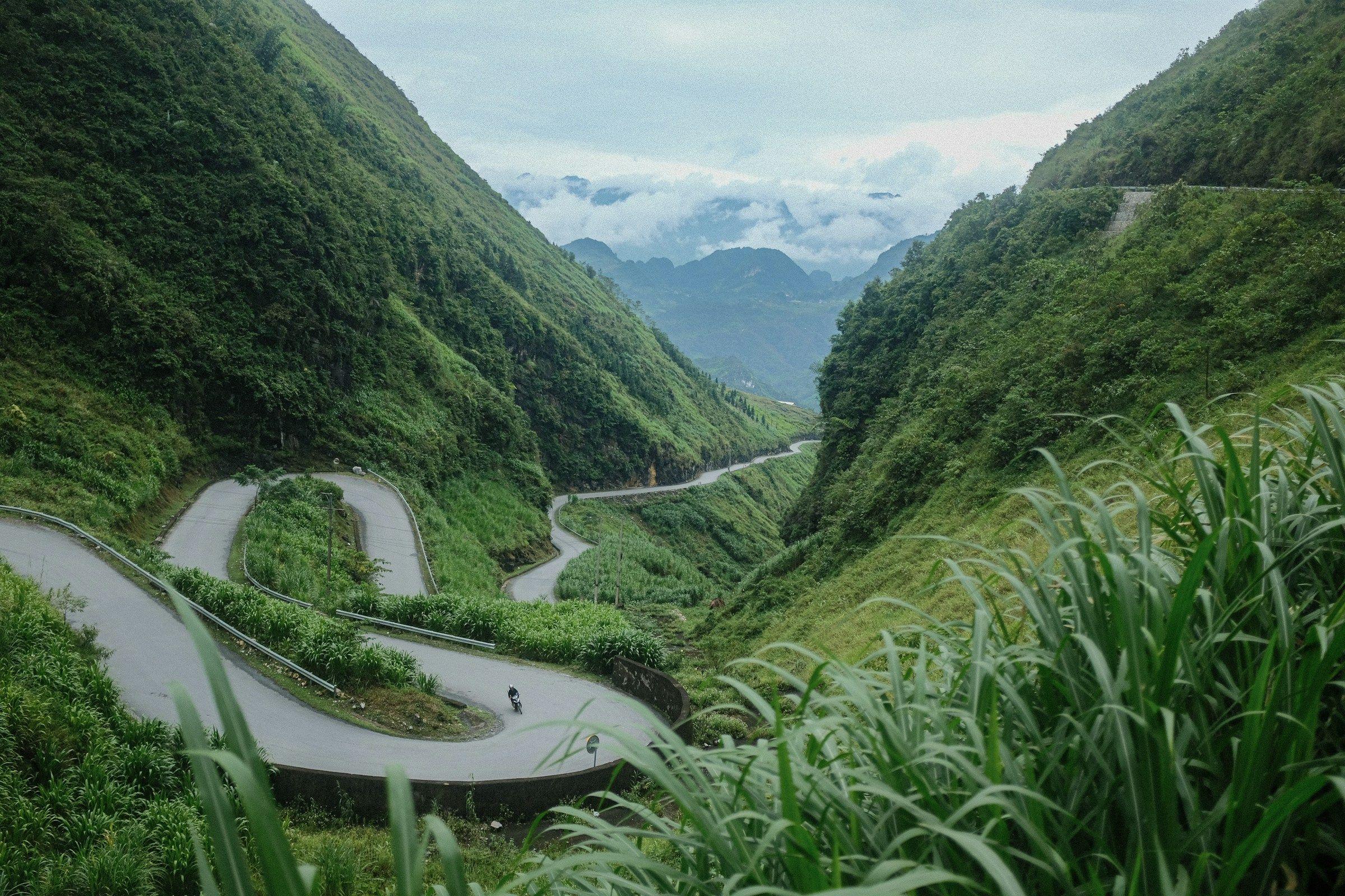
The roads are narrow, curvy, and really beautiful, embracing cliffs or head into valleys - so cycling here can be a demanding experience. In rainy seasons, there can be landslides, road erosion. This rugged, varied landscape of Ha Giang also means cyclings can be awed with striking views when you cycle up and down its various roads.
History: A borderland shaped by quiet endurance
Ha Giang is more known for its majestic terrain than its historic role, but it has a really unique history, combining its own local history of various tribes and kingdoms, and its role as a vein in the greater flow of Vietnam history, when it was integrated into dynasties of Vietnam via military campaigns and political treaties.
When France colonized Vietnam, between late 19th century and early 20th century, Ha Giang played a strategic role thanks to its position on the border. When the border war between Vietnam and China happened in 1979, there were more military activities here, and nowadays people can still see the remnants of that war, via some bunkers or outposts.
The fabric of Ha Giang history, therefore, is the consistent flow of its tribal history and its engagement in some key events in Vietnam’s history. As we cycle through the region, we can feel its history via the landscape itself - curvy stone roads, terraced fields, remote villages that stand the test of time and the brutality of history.
Culture - A diverse mosaic
Ha Giang is really diverse in terms of ethnicity. There are more than 20 ethnic groups living here, notably he Hmong, Tay, Dao, Nung, and Giay, all still preserving their traditional languages, clothing, housing styles, and daily practice.
In this region, people maintain their ways of living via agriculture. Since the terrain is harsh, agriculture practice here is more labor-intensive and physically demanding than flat regions. People still grow crops on mountains like maize, rice, and vegetables. They also raise animals, weave textiles, and trade on a small scale. As it is not easy for people to travel and meet up, people often meet in weekend markets - which turns it into a socially significant event - where not only goods are exchanged, sold and bought, but also where new relationships and love are formed.
Due to difficulty of access, education infrastructures here are not so good, though teachers alternate to stay in the region to teach the students. Most communities here follow their own festivals based on the lunar calendar. They have their own world view and beliefs in supernatural spirits, aside from ancestor worships that are quite similar to the rest of Vietnam.
In recent years, aside from the efforts to integrate and develop the economy, there have been parallel efforts to preserve its cultures and customs, backed by efforts from grassroot NGOs.
HA GIANG ATTRACTIONS
1. Dong Van Karst Plateau Geopark, a UNESCO Global Geopark.
- Dong Van Karst Plateau Geopark is a Geopark located in several districts of Ha Giang, including Dong Van, Meo Vac, Yen Minh, and Quan Ba. It covers an area of more than 2,300 square kilometers, with an altitude ranging from 1,400 to 1,600 meters above sea level, and mostly covered by limestones that date back 400 to 600 million years. The topography is epic, formed by a combination of karst peaks, deep canyons, rock plateaus, caves, and fossils. In 2010, it was recognized as a UNESCO Global Geopark, the first of its kind in Vietnam and 2nd one in South East Asia.
- This site has a really long history and rich geological history. More than 80% of the area is limestone, altogether forming an epic karst landscape. According to researchers, these rock formations were created from the Cambrian to the Permian periods, which is about 500–250 million years ago. Even on such high elevation, there are still some fossils containing evidence of ancient marine life, when the area was under the sea.
- Here, roads are narrow, with sharp twists and turns, offering spectacular views on communities and regions below.
2. Lung Tam village
Lung Tam Commune is located in Quan Ba District, 50km to the north of Ha Giang City. This is home to more than 100 households, mainly H’Mong people.
This is a village with an interesting linen and brocade weaving tradition. The tradition contains 41 steps, all tone by hand, using flax grown right at the village. This village has a pretty sustainable handicraft model since it manages to form a cooperative, The Lung Tam Linen Cooperative, which was established in 2001, where more than 120–150 artisans using 120+ looms collectively work. Together, they produce a variety of products: clothing, bags, wallets, and home textiles, often hand‑dyed with natural materials (indigo, beeswax, plant extracts) that are exported to more than 20 countries in the world.
To H’Mong people here, mastering the art of linen weaving marks an important step in their personal growth - as H’mong women need to master this before they can properly get married. Coming here, we can watch the whole process and interact with artisans.
3. Vuong King Palace
Located within the territory of the Dong Van Karst Plateau Geopark, Vuong King Palace is a wonderful architectural formation.
The site was built from 1898 to 1907 by a powerful H’Mong figure named Vuong Chinh Duc, also known as a H’Mong king. It was built as his home but also like a fortress, signifying the political and economic power of H’mong people, and costing up to 150,000 Indochinese silver coins (equal to around $6 million today)
The architectural style of this site is an interesting blend of Chinese, French, and Hmong styles. It is built from stone, terracotta tiles, and pine wood. It is built in an orderly, symmetrical way, divided into front, middle, and rear sections, embraced with three courtyards. thick stone walls, watchtowers, bunkers, opium and weapons storage, resembling a fortress.
The details inside are intricate, with elaborate carvings of dragons, phoenixes, bats, and even opium poppy motifs. In 1993, it was recognized as a National Architectural Heritage
4. Happiness Road
Happiness Road is a road that is epic in its layout and significant in its history. It is nearly 200 km, connecting Hà Giang City to Mèo Vạc and passing by Quản Bạ, Yên Minh, and Đồng Văn. It is an epic road, carved directly into mountains, embracing cliffsides, looking over deep valleys and towards limestone peaks. It was built between 1959 and 1965 when this region was still greatly disconnected from the rest of Vietnam. It is a testament of collective efforts of so many people, nearly 1,3000 volunteers, both in ethnic groups and non-ethnic groups, working day and night, in harsh conditions. Over a dozen workers died during the process, and at one section there is a monument to honor them. The road is a testament to national solidarity and human resilience in the 20th century, when Vietnam was in the process of building their socialist country.
5. Dong Van town
Dong Van town is a lovely town nestled amidst rocky mountain peaks, as part of the Dong Van Karst Plateau Geopark, a UNESCO Global Geopark. It’s a lovely town where many ethnic groups live together, including the Hmong, Dao, Tày, Lô Lô. They join colorful weekend markets, wearing traditional dresses, and live in earthen and stone houses that blend Hmong and Han Chinese architectural styles. The town is located quite close to Mã Pí Lèng Pass, Lũng Cú Flag Tower, and villages nearby.
6. Ma Pi Leng Pass
Ma Pi Leng Pass is 20 km long and around 1500 meters high. It is part of the iconic Happiness Road. The name Ma Pi Leng is a H’Mong word that means “horses cannot cross”, referring to its steepness. The pass overlooks Nho Quế River Gorge, with dramatic views. Vietnamese call Ma Pi Leng one of “tứ đại đỉnh đèo”, one of “Four Great Passes”. It is truly dramatic, as the road is carved directly into limestone rock, and some parts of this pass are built along mountain surfaces that stand erect.
7. Nho Que River
Nho Que river starts from Yunnan, China, flows to Vietnam, winding through deep Tu San Canyon, right under Ma Pi Leng Pass. This location makes it one of the most spectacular river gorges in Southeast Asia. The river has deep green colors, almost like a jewel in the mountain area. It is both a natural border and also provides water for ethnic communities in the vicinity. Currently, part of the river can be reached by boats, and cruising the river on this vehicle is a visceral experience.
Written by
Manager
Share this post